LOCATION AND ACCESS
These typical sedimentary platforms are to be found to the south of the pass of Puerto Llano along the road (EX-116) leading from Guadalupe to Villanueva de la Serena.
Geoparque Mundial UNESCO
Geoparque Villuercas > Nº05 – Rañas de Cañamero
These typical sedimentary platforms are to be found to the south of the pass of Puerto Llano along the road (EX-116) leading from Guadalupe to Villanueva de la Serena.
We will observe the geomorphology of these sedimentary deposits, which is very simple, as they always give rise to extensive platforms, “mesas” or plateaus, separated from each other by the deep enclaves of the current hydrographic network, in this case of the Cubilar river (a tributary of the Guadiana river) in the poorly consolidated and easily eroded materials that make up the rañas and the underlying Cenozoic materials.
Due to their geological characteristics they are not very rich soils, which is why they have traditionally been used to grow vines and olive trees.
Their altitude varies between 600 and 550 metres with gentle inclination from the horizontal of approximately 7%, which contrasts with the steep slopes of the quartzite sierras and, when there is lateral continuity, they link up with their erosive slopes.
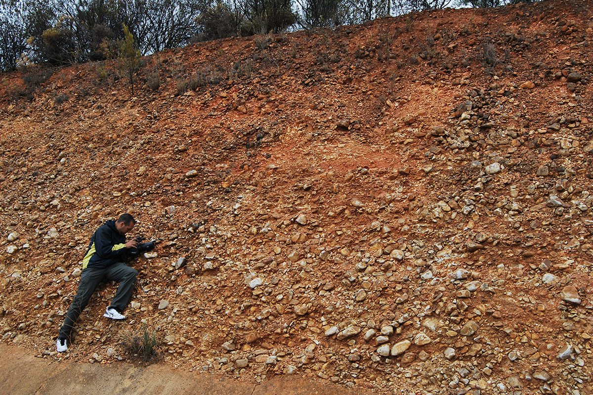
These are the most singular sedimentary deposits of continental origin in Las Villuercas. They are made up of unconsolidated fanglomerates that include numerous sub-rounded heterometric blocks and pebbles embedded in a reddish-yellowish sandy clayey matrix. The cobbles are mainly derived from the more resistant Palaeozoic materials with a predominance of quartzite clasts. The fanglomerates are not very permeable due to their clayey matrix and are easily eroded by run-off water.
The rañas are the result of the accumulation, on the saturated materials of the Neogene basins, of materials transported by the fluvial waters at the headwaters of the hydrographic network. Recent data indicate an early Quaternary age (base of the Pleistocene) for these deposits.
They are considered to be piedmont deposits (large alluvial fans overlapping one another) with a very flat top, whose materials come from the nearby mountain ranges with which they are linked and to which they are attached. They currently have a characteristic lobate morphology in plan view, as a result of fluvial erosion of these deposits and the underlying Cenozoic materials.
Their origin is linked to heavy rainfall, which eroded the rocks of the higher reliefs, dragging a large amount of material along the courses of their narrow valleys. When these steeply sloping channels reached the wide plains, filled with the Neogene fluvial-lake sediments of the Guadiana endorheic basin, their energy abruptly diminished and the courses opened up into wide fans with a large number of channels where the transported materials were deposited. The Cañamero rañas are considered to be one of the most spectacular formations of this type on the Iberian Peninsula. Its genesis has been related to a peculiar climatology that coincides with the beginning of the Quaternary glaciations in the northern hemisphere, with new, colder conditions and significant rainfall.
The formation of the current hydrographic network, which has shaped its current morphology, began with the transition from an endorheic to an exorheic basin, caused by the significant drop in sea level (approximately 100 metres) produced by the great accumulation of ice in the northern hemisphere at the beginning of the Quaternary. The ravines and poorly consolidated sediments of the Neogene began to erode rapidly, leaving a new type of deposit, the fluvial terraces (see Geosite 54). In many cases the rañas are mistaken for the oldest terrace of the rivers. However, there are two criteria that allow their differentiation. The terrace is always located at a lower level than the raña. In the case of the rañas in the Guadiana basin (Cañamero-Logrosan, Alia and Puerto Rey), they are located between approximately 620 metres in the areas close to the Palaeozoic reliefs and 540 metres in the more distal areas. Another important characteristic is their arrangement in palaeochannels and the high permeability of the fluvial sediments, typical of an exorheic basin where the fine clayey sediments are transported by the long channels, giving rise to cleaner and more permeable gravels and sands. The coarser materials of the rañas come from the quartzites, whose fragmentation produces the pebbles and blocks, while the greywackes, slates or shales break up to form the clayey-sandy matrix. The thickness of this formation varies greatly, from 5 to 10 m, as in the case of the Mesillas and Cañamero rocks.
In the Guadiana Basin, below the quartzite fanglomerates of the rañas, we find materials attributed to the Neogene, which are divided into two units. A lower unit of Early-Middle Miocene age, which includes conglomerates, sandstones and red siltstones in the areas close to the edge of the basin (e.g. SE of Logrosan) and sandstones and red siltstones in the rest of the basin. This unit is equivalent to the Lobón Facies of the Badajoz area. On top of this unit, the upper unit of Late Miocene-Pliocene age is discordant and includes quartzite blocks and conglomerates, sandstones and red mudstones at the edge of the basin and gravels, sandstones and red mudstones in the more distant areas. This unit would be equivalent to the Almendralejo Facies and can be observed on the slopes of the road from Villanueva de La Serena to Guadalupe, in the municipality of Logrosán.
In the case of the Cañamero and Logrosán rañas, as can be well seen in satellite images, they constitute an extensive triangular plain, open to the south and with the upper vertex pointing towards the wide syncline of the Ruecas river valley.