


From this site and following the path nearest to the Tajo (see map) we come to the defile after about 2 km. The defile is about 750 metres long from where it begins at an old mill to where it flows into the Tajo.
The granite we find on the way and in the defile comes from magma which rose from the centre of the Earth in the form of dikes some 320 million years ago; this event was related to the Hercynian orogeny 380-230 million years ago. The magma cooled before emerging onto the surface and fractured owing to various chemical reactions.
Now we can observe this granite on the surface because it is much more resistant to erosion than the soft rocks of the ancient sea beds which covered and surrounded it. The latter are older, being from the Upper Ediacaran and Lower Cambrian.
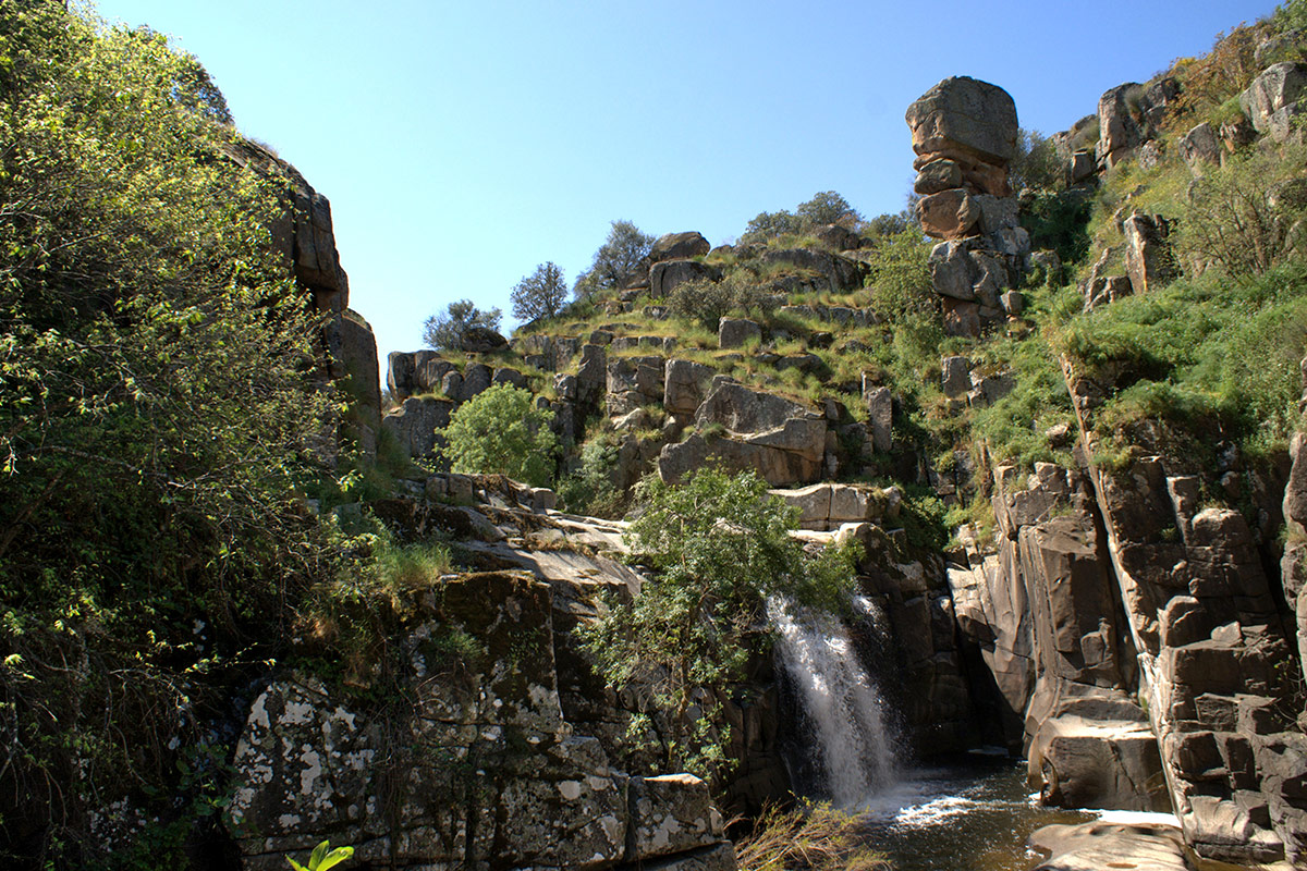
The erosive action of water on the granite by making use of the ancient fractures has meant that the stream has gradually been embedded to form the defile; at the same time the softer rocks have been eroded to form an extensive peneplain.
Near the village of Villar del Pedroso the granite is coarse-grained with two micas and large crystals of orthose feldspar. However, where the El Pedroso Stream has excavated its deep bed the granite is very fine-grained and consists of aplites («microgranite») which are very resistant to erosion. These rocks are very hard albeit intensely fractured by a system of perpendicular diaclases (fractures), which facilitates their fragmentation into blocs and the embedment of the El Pedroso Stream which seeks its base level in the trench of the Tajo. These aplites rise as huge rock walls many metres high which have resisted erosion and maintain an uneasy balance.
The granites between Villar del Pedroso and El Puente del Arzobispo are covered with sediments from the Pliocene-Pleistocene (3.5-2.5 million years old) which are known as rañas; these consist of pebbles of different types united by a red clayey matrix.
We can observe the curious erosive rock shapes of the berrocal which are the result of the chemical and mechanical weathering of the granite rocks: the rounded blocks, the «mushroom stones», and the tors, together with the various fracture planes (diaclases) which have determined the formation of blocks of different sizes.
The embedment of the El Pedroso Stream in these rocks is spectacular and forms rapids, waterfalls, and potholes. When the level of the water of the stream is high it is impossible to pass to the opposite bank; the roar of the water falling into the deep canyon is awe-inspiring.
Finally we can complete the excursion by making a visit to the nearby ruins of several old mills and the impressive Fuerte de Castros and its walls, the pillars of the bridge over the River Tajo, and the settlement of the surrounding area. The Fuerte is a Moslem fortress which was erected in the 10th century near the Islamic town of Vascos in order to defend the middle frontier of the Tajo.
In a plaza of Villar del Pedroso we can also admire various zoomorphic sculptures (“verracos”) of the Vetton people of the Iron Age together with numerous Roman inscriptions of great archaeological interest.